Watervliet night lights from space
Night Light of Watervliet (New York) from space (United States) Src. Average luminocity for 10x10km area is 73.2788% and for 50x50km: 22.7195%.
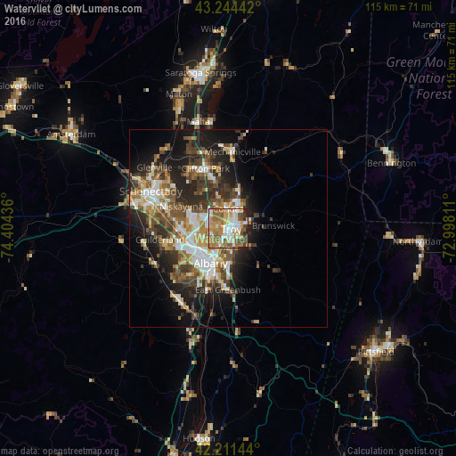
Analysis of Watervliet night lights 2016
Square area 10x10 km:
 14.55%
90-99
17.42%80-89
8.94%70-79
16.67%60-69
16.36%50-59
12.27%40-49
5%30-39
3.94%20-29
4.55%10-19
0.3%0-9
0%Square area 50x50 km:
3.54%90-99
3.97%80-89
2.58%70-79
2.92%60-69
3.06%50-59
3.75%40-49
4.27%30-39
3.97%20-29
6.68%10-19
10.15%0-9
55.11%Clear (daylight) street map image can be seen on geolist.org.
Map coordinates:
43° 14' 39.9" North, 74° 24' 15.7" West
42° 43' 48.3" North, 73° 42' 4.4" West
42° 12' 41.2" North, 72° 59' 53.2" West
Some cities around Watervliet sort by population:
• Albany
9.7 km =6 mi,  207°
207°
• West Albany
8.2 km =5.1 mi,  230°
230°
• Troy
0.8 km =0.5 mi,  103°
103°
• Latham
5.1 km =3.2 mi,  291°
291°
• Cohoes
4.9 km =3 mi,  1°
1°
• Roessleville
9.5 km =5.9 mi,  245°
245°
• Rensselaer
10.3 km =6.4 mi,  199°
199°
• Colonie
10.9 km =6.8 mi,  262°
262°
4833276 (p: 10,214)
Sources (retrieved 2019-11-25):
» Earth at Night: Flat Maps 2012, 2016