Roessleville night lights from space
Night Light of Roessleville (New York) from space (United States) Src. Average luminocity for 10x10km area is 83.4545% and for 50x50km: 22.8913%.
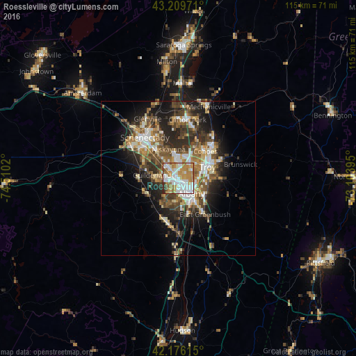
Analysis of Roessleville night lights 2016
Square area 10x10 km:
 27.42%
90-99
22.58%80-89
8.64%70-79
20.15%60-69
11.36%50-59
5.15%40-49
1.06%30-39
2.42%20-29
1.21%10-19
0%0-9
0%Square area 50x50 km:
3.54%90-99
3.98%80-89
2.72%70-79
2.95%60-69
3.14%50-59
3.89%40-49
4.21%30-39
3.97%20-29
6.63%10-19
9.37%0-9
55.62%Clear (daylight) street map image can be seen on geolist.org.
Map coordinates:
43° 12' 35" North, 74° 30' 36.7" West
42° 41' 42.3" North, 73° 48' 25.5" West
42° 10' 34.1" North, 73° 6' 14.2" West
Some cities around Roessleville sort by population:
• Albany
6.3 km =3.9 mi,  138°
138°
• West Albany
2.7 km =1.7 mi,  119°
119°
• Latham
7 km =4.3 mi,  34°
34°
• Watervliet
9.5 km =5.9 mi,  65°
65°
• Rensselaer
7.8 km =4.8 mi, 138°
• Delmar
8.4 km =5.2 mi,  194°
194°
• Colonie
3.3 km =2.1 mi,  319°
319°
• Westmere
5.1 km =3.2 mi,  265°
265°
5134257 (p: 10,753)
Sources (retrieved 2019-11-25):
» Earth at Night: Flat Maps 2012, 2016