Washington night lights from space
Night Light of Washington (Illinois) from space (United States) Src. Average luminocity for 10x10km area is 24.9692% and for 50x50km: 19.0127%.
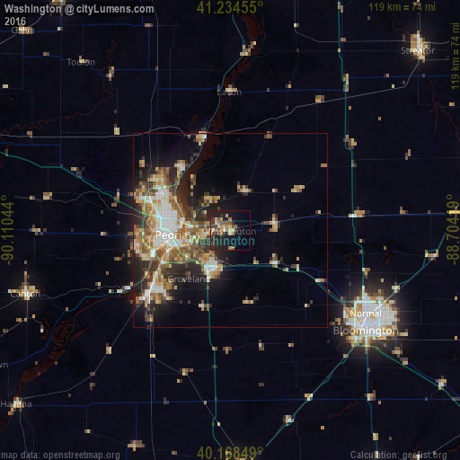
Analysis of Washington night lights 2016
Square area 10x10 km:
 0.49%
0.49%90-99
1.46%80-89
5.52%70-79
1.79%60-69
5.36%50-59
4.71%40-49
4.38%30-39
4.06%20-29
13.15%10-19
22.08%0-9
37.01%Square area 50x50 km:
2.27%90-99
2.97%80-89
2.92%70-79
2.6%60-69
3.12%50-59
3.25%40-49
3.03%30-39
3.12%20-29
5.2%10-19
7.46%0-9
64.07%Clear (daylight) street map image can be seen on geolist.org.
Map coordinates:
41° 14' 4.4" North, 90° 6' 37.6" West
40° 42' 13.1" North, 89° 24' 26.3" West
40° 10' 6.6" North, 88° 42' 15.1" West
Some cities around Washington sort by population:
• Peoria
15.4 km =9.6 mi,  265°
265°
• North Peoria
15 km =9.3 mi,  275°
275°
• East Peoria
15.2 km =9.4 mi,  254°
254°
• Morton
11 km =6.8 mi,  203°
203°
• Bartonville
21.5 km =13.4 mi, 253°
• Peoria Heights
14.9 km =9.3 mi,  289°
289°
• Eureka
11.5 km =7.1 mi,  80°
80°
• Creve Coeur
16.7 km =10.4 mi, 247°
4915545 (p: 16,664)
Sources (retrieved 2019-11-25):
» Earth at Night: Flat Maps 2012, 2016