Bartonville night lights from space
Night Light of Bartonville (Illinois) from space (United States) Src. Average luminocity for 10x10km area is 63.0503% and for 50x50km: 18.4654%.
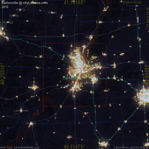
Analysis of Bartonville night lights 2016
Square area 10x10 km:
 10.88%
90-99
10.23%80-89
11.69%70-79
10.71%60-69
11.53%50-59
13.15%40-49
7.47%30-39
10.55%20-29
9.09%10-19
4.71%0-9
0%Square area 50x50 km:
2.24%90-99
2.91%80-89
2.68%70-79
2.33%60-69
2.97%50-59
3.32%40-49
2.83%30-39
3.18%20-29
5.28%10-19
8.99%0-9
63.26%Clear (daylight) street map image can be seen on geolist.org.
Map coordinates:
41° 10' 53.9" North, 90° 21' 18.6" West
40° 39' 1.2" North, 89° 39' 7.4" West
40° 6' 53" North, 88° 56' 56.1" West
Some cities around Bartonville sort by population:
• Peoria
7.2 km =4.5 mi,  47°
47°
• North Peoria
9.4 km =5.8 mi,  37°
37°
• Pekin
9.3 km =5.8 mi,  174°
174°
• East Peoria
6.3 km =3.9 mi,  73°
73°
• Washington
21.5 km =13.4 mi, 73°
• Morton
16.8 km =10.4 mi,  104°
104°
• Peoria Heights
12.6 km =7.8 mi,  31°
31°
• Creve Coeur
5.1 km =3.2 mi,  93°
93°
4884161 (p: 6,382)
Sources (retrieved 2019-11-25):
» Earth at Night: Flat Maps 2012, 2016