Eureka night lights from space
Night Light of Eureka (Illinois) from space (United States) Src. Average luminocity for 10x10km area is 9.0049% and for 50x50km: 10.9125%.
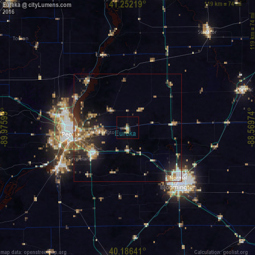
Analysis of Eureka night lights 2016
Square area 10x10 km:
 0%
0%90-99
0.65%80-89
1.62%70-79
2.6%60-69
0.32%50-59
1.3%40-49
1.95%30-39
0.32%20-29
2.44%10-19
1.79%0-9
87.01%Square area 50x50 km:
0.85%90-99
1.14%80-89
1.95%70-79
1.51%60-69
1.68%50-59
1.66%40-49
1.98%30-39
1.7%20-29
3.83%10-19
5.65%0-9
78.07%Clear (daylight) street map image can be seen on geolist.org.
Map coordinates:
41° 15' 7.9" North, 89° 58' 33.6" West
40° 43' 17.1" North, 89° 16' 22.3" West
40° 11' 11.1" North, 88° 34' 11.1" West
Some cities around Eureka sort by population:
• Peoria
26.8 km =16.7 mi,  263°
263°
• North Peoria
26.2 km =16.3 mi,  269°
269°
• East Peoria
26.6 km =16.5 mi, 256°
• Washington
11.5 km =7.1 mi, 260°
• Morton
19.8 km =12.3 mi,  232°
232°
• Chillicothe
28.7 km =17.8 mi,  321°
321°
• Peoria Heights
25.5 km =15.8 mi,  276°
276°
• Creve Coeur
28.1 km =17.5 mi,  252°
252°
4891310 (p: 5,377)
Sources (retrieved 2019-11-25):
» Earth at Night: Flat Maps 2012, 2016