Washington Court House night lights from space
Night Light of Washington Court House (Ohio) from space (United States) Src. Average luminocity for 10x10km area is 31.0162% and for 50x50km: 3.0579%.
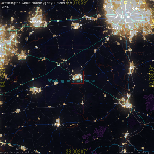
Analysis of Washington Court House night lights 2016
Square area 10x10 km:
 4.38%
4.38%90-99
5.36%80-89
6.17%70-79
3.08%60-69
3.08%50-59
3.08%40-49
3.41%30-39
3.41%20-29
2.11%10-19
40.58%0-9
25.32%Square area 50x50 km:
0.26%90-99
0.44%80-89
0.57%70-79
0.36%60-69
0.38%50-59
0.38%40-49
0.34%30-39
0.42%20-29
0.48%10-19
1.88%0-9
94.48%Clear (daylight) street map image can be seen on geolist.org.
Map coordinates:
40° 4' 35.7" North, 84° 8' 32" West
39° 32' 11.2" North, 83° 26' 20.7" West
38° 59' 31.5" North, 82° 44' 9.5" West
Some cities around Washington Court House sort by population:
• Grove City
48.5 km =30.1 mi,  37°
37°
• Xenia
45.1 km =28 mi,  291°
291°
• Chillicothe
45.3 km =28.1 mi,  119°
119°
• Circleville
42.9 km =26.7 mi,  80°
80°
• Wilmington
34.9 km =21.7 mi,  253°
253°
• London
38.9 km =24.2 mi,  358°
358°
• Lincoln Village
53.5 km =33.2 mi,  29°
29°
• Hillsboro
40 km =24.9 mi,  201°
201°
4527660 (p: 14,019)
Sources (retrieved 2019-11-25):
» Earth at Night: Flat Maps 2012, 2016