London night lights from space
Night Light of London (Ohio) from space (United States) Src. Average luminocity for 10x10km area is 27.7398% and for 50x50km: 7.6738%.
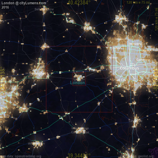
Analysis of London night lights 2016
Square area 10x10 km:
 3.23%
3.23%90-99
5.95%80-89
6.8%70-79
3.06%60-69
2.89%50-59
2.38%40-49
0.34%30-39
0.85%20-29
1.7%10-19
35.54%0-9
37.24%Square area 50x50 km:
0.79%90-99
1.17%80-89
0.79%70-79
0.93%60-69
1.08%50-59
0.95%40-49
1.07%30-39
1.34%20-29
2.11%10-19
5.99%0-9
83.79%Clear (daylight) street map image can be seen on geolist.org.
Map coordinates:
40° 25' 25.8" North, 84° 9' 5" West
39° 53' 11.2" North, 83° 26' 53.7" West
39° 20' 41.3" North, 82° 44' 42.5" West
Some cities around London sort by population:
• Springfield
31 km =19.3 mi,  277°
277°
• Grove City
30.3 km =18.8 mi,  91°
91°
• Upper Arlington
35 km =21.7 mi,  69°
69°
• Hilliard
29.6 km =18.4 mi,  56°
56°
• Urbana
35.8 km =22.2 mi,  313°
313°
• Lincoln Village
28.1 km =17.5 mi, 74°
• Northridge
30.5 km =19 mi,  292°
292°
• Grandview Heights
36.3 km =22.6 mi, 73°
4517009 (p: 10,060)
Sources (retrieved 2019-11-25):
» Earth at Night: Flat Maps 2012, 2016