Wapakoneta night lights from space
Night Light of Wapakoneta (Ohio) from space (United States) Src. Average luminocity for 10x10km area is 22% and for 50x50km: 9.794%.
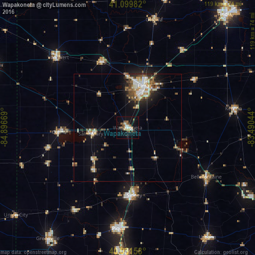
Analysis of Wapakoneta night lights 2016
Square area 10x10 km:
 2.11%
2.11%90-99
3.9%80-89
2.44%70-79
0.65%60-69
4.38%50-59
5.52%40-49
1.3%30-39
3.25%20-29
3.08%10-19
19.32%0-9
54.06%Square area 50x50 km:
1.25%90-99
1.95%80-89
1.17%70-79
1.02%60-69
1.1%50-59
1.19%40-49
1.64%30-39
1.34%20-29
2.14%10-19
4.6%0-9
82.58%Clear (daylight) street map image can be seen on geolist.org.
Map coordinates:
41° 5' 59.4" North, 84° 53' 48.1" West
40° 34' 4.2" North, 84° 11' 36.8" West
40° 1' 53.7" North, 83° 29' 25.6" West
Some cities around Wapakoneta sort by population:
• Lima
20.8 km =12.9 mi,  20°
20°
• Sidney
31.7 km =19.7 mi,  174°
174°
• Bellefontaine
43.3 km =26.9 mi,  122°
122°
• Celina
31.9 km =19.8 mi,  266°
266°
• Saint Marys
16.8 km =10.4 mi,  260°
260°
• Delphos
33.1 km =20.6 mi,  337°
337°
• Ada
38.5 km =23.9 mi,  54°
54°
• Northwood
40.4 km =25.1 mi,  105°
105°
5175670 (p: 9,823)
Sources (retrieved 2019-11-25):
» Earth at Night: Flat Maps 2012, 2016