Lima night lights from space
Night Light of Lima (Ohio) from space (United States) Src. Average luminocity for 10x10km area is 77.1948% and for 50x50km: 9.5908%.
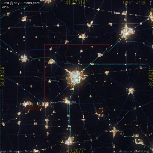

Analysis of Lima night lights 2016
Square area 10x10 km:
 21.75%
90-99
25.32%80-89
9.58%70-79
9.25%60-69
7.47%50-59
7.47%40-49
7.79%30-39
5.36%20-29
5.68%10-19
0.32%0-9
0%Square area 50x50 km:
1.23%90-99
1.79%80-89
1.17%70-79
1.13%60-69
1.29%50-59
1.01%40-49
1.55%30-39
1.21%20-29
2.22%10-19
4.98%0-9
82.41%Clear (daylight) street map image can be seen on geolist.org.
Map coordinates:
41° 16' 23.3" North, 84° 48' 30.1" West
40° 44' 33.2" North, 84° 6' 18.8" West
40° 12' 27.7" North, 83° 24' 7.6" West
Some cities around Lima sort by population:
• Van Wert
42.7 km =26.5 mi,  289°
289°
• Celina
44.7 km =27.8 mi,  241°
241°
• Wapakoneta
20.8 km =12.9 mi,  200°
200°
• Saint Marys
32.7 km =20.3 mi,  227°
227°
• Kenton
43.1 km =26.8 mi,  104°
104°
• Delphos
22.8 km =14.2 mi,  299°
299°
• Ada
24 km =14.9 mi,  82°
82°
• Northwood
43.5 km =27 mi,  133°
133°
5160783 (p: 37,873)
Sources (retrieved 2019-11-25):
» Earth at Night: Flat Maps 2012, 2016