Walled Lake night lights from space
Night Light of Walled Lake (Michigan) from space (United States) Src. Average luminocity for 10x10km area is 68.2063% and for 50x50km: 52.133%.
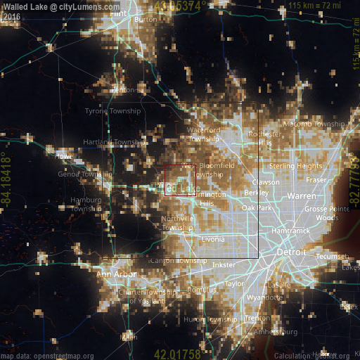
Analysis of Walled Lake night lights 2016
Square area 10x10 km:
 10.32%
90-99
11.75%80-89
7.62%70-79
11.59%60-69
20.48%50-59
20%40-49
13.97%30-39
0.63%20-29
3.65%10-19
0%0-9
0%Square area 50x50 km:
12.2%90-99
11.83%80-89
5.11%70-79
6.78%60-69
9.68%50-59
8.34%40-49
6.37%30-39
4.62%20-29
6.47%10-19
12.1%0-9
16.52%Clear (daylight) street map image can be seen on geolist.org.
Map coordinates:
43° 3' 13.5" North, 84° 11' 3" West
42° 32' 16.1" North, 83° 28' 51.8" West
42° 1' 3.3" North, 82° 46' 40.5" West
Some cities around Walled Lake sort by population:
• Farmington Hills
10.3 km =6.4 mi,  124°
124°
• West Bloomfield Township
8.7 km =5.4 mi,  66°
66°
• Novi
6.4 km =4 mi,  175°
175°
• Wixom
4.8 km =3 mi,  252°
252°
• South Lyon
16.4 km =10.2 mi,  238°
238°
• Farmington
11.8 km =7.3 mi,  133°
133°
• Milford
11.5 km =7.1 mi,  302°
302°
• Northville
11.9 km =7.4 mi, 180°
5013961 (p: 7,110)
Sources (retrieved 2019-11-25):
» Earth at Night: Flat Maps 2012, 2016