Milford night lights from space
Night Light of Milford (Michigan) from space (United States) Src. Average luminocity for 10x10km area is 27.8091% and for 50x50km: 34.4523%.
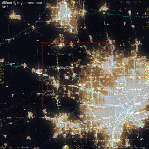
Analysis of Milford night lights 2016
Square area 10x10 km:
 0.45%
0.45%90-99
0.61%80-89
2.58%70-79
2.42%60-69
2.58%50-59
5%40-49
3.94%30-39
13.64%20-29
17.88%10-19
50.91%0-9
0%Square area 50x50 km:
4.38%90-99
5.45%80-89
3.36%70-79
4.9%60-69
7.1%50-59
7.72%40-49
6.39%30-39
5.28%20-29
6.87%10-19
15.61%0-9
32.94%Clear (daylight) street map image can be seen on geolist.org.
Map coordinates:
43° 6' 32.8" North, 84° 18' 9.1" West
42° 35' 37.1" North, 83° 35' 57.8" West
42° 4' 25.9" North, 82° 53' 46.6" West
Some cities around Milford sort by population:
• Waterford
18.9 km =11.7 mi,  54°
54°
• West Bloomfield Township
17.9 km =11.1 mi,  98°
98°
• Novi
16.2 km =10.1 mi,  141°
141°
• Wixom
9.2 km =5.7 mi,  146°
146°
• South Lyon
15.4 km =9.6 mi,  196°
196°
• Brighton
16.4 km =10.2 mi,  244°
244°
• Walled Lake
11.5 km =7.1 mi,  122°
122°
• Northville
20.4 km =12.7 mi, 152°
5001972 (p: 6,472)
Sources (retrieved 2019-11-25):
» Earth at Night: Flat Maps 2012, 2016