South Lyon night lights from space
Night Light of South Lyon (Michigan) from space (United States) Src. Average luminocity for 10x10km area is 33.1159% and for 50x50km: 40.2542%.
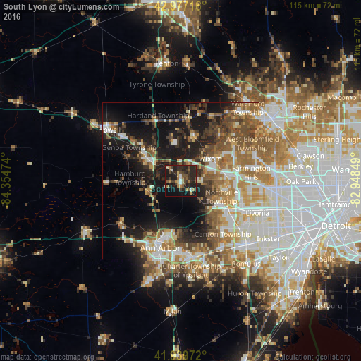
Analysis of South Lyon night lights 2016
Square area 10x10 km:
 2.22%
2.22%90-99
2.22%80-89
2.7%70-79
3.97%60-69
5.56%50-59
5.56%40-49
7.78%30-39
8.1%20-29
24.29%10-19
29.37%0-9
8.25%Square area 50x50 km:
6.02%90-99
7.86%80-89
4.86%70-79
5.71%60-69
7.51%50-59
7.03%40-49
6.11%30-39
4.92%20-29
7.75%10-19
17.07%0-9
25.16%Clear (daylight) street map image can be seen on geolist.org.
Map coordinates:
42° 58' 37.8" North, 84° 21' 17.1" West
42° 27' 38.1" North, 83° 39' 5.8" West
41° 56' 23" North, 82° 56' 54.6" West
Some cities around South Lyon sort by population:
• Novi
14.6 km =9.1 mi,  81°
81°
• Wixom
11.8 km =7.3 mi,  52°
52°
• Plymouth
17.9 km =11.1 mi,  123°
123°
• Brighton
13 km =8.1 mi,  305°
305°
• Walled Lake
16.4 km =10.2 mi,  58°
58°
• Milford
15.4 km =9.6 mi,  16°
16°
• Whitmore Lake
8 km =5 mi,  253°
253°
• Northville
14.2 km =8.8 mi,  103°
103°
5010548 (p: 11,722)
Sources (retrieved 2019-11-25):
» Earth at Night: Flat Maps 2012, 2016