Walker Mill night lights from space
Night Light of Walker Mill (Maryland) from space (United States) Src. Average luminocity for 10x10km area is 96.352% and for 50x50km: 66.4263%.
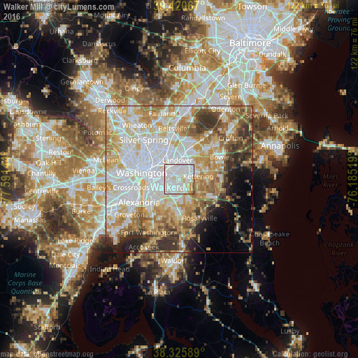
Analysis of Walker Mill night lights 2016
Square area 10x10 km:
 57.65%
90-99
26.87%80-89
10.03%70-79
4.08%60-69
1.36%50-59
0%40-49
0%30-39
0%20-29
0%10-19
0%0-9
0%Square area 50x50 km:
20.76%90-99
15.13%80-89
10.04%70-79
10.33%60-69
8.25%50-59
6.52%40-49
4.55%30-39
5.56%20-29
4.29%10-19
4.23%0-9
10.33%Clear (daylight) street map image can be seen on geolist.org.
Map coordinates:
39° 25' 14.4" North, 77° 35' 29.2" West
38° 52' 31.4" North, 76° 53' 17.9" West
38° 19' 33.2" North, 76° 11' 6.7" West
Some cities around Walker Mill sort by population:
• Suitland-Silver Hill
4.5 km =2.8 mi,  225°
225°
• Suitland
4.3 km =2.7 mi, 226°
• Forestville
3.6 km =2.2 mi,  161°
161°
• Summerfield
3.7 km =2.3 mi,  28°
28°
• Largo
5.6 km =3.5 mi,  63°
63°
• Coral Hills
2.9 km =1.8 mi,  258°
258°
• Lake Arbor
6.2 km =3.9 mi,  54°
54°
• District Heights
2 km =1.2 mi,  182°
182°
4372623 (p: 11,302)
Sources (retrieved 2019-11-25):
» Earth at Night: Flat Maps 2012, 2016