Waconia night lights from space
Night Light of Waconia (Minnesota) from space (United States) Src. Average luminocity for 10x10km area is 15.2556% and for 50x50km: 13.4802%.
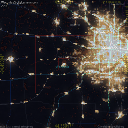
Analysis of Waconia night lights 2016
Square area 10x10 km:
 1.9%
1.9%90-99
1.9%80-89
3.17%70-79
1.27%60-69
1.9%50-59
0.63%40-49
0.63%30-39
1.9%20-29
2.54%10-19
6.19%0-9
77.94%Square area 50x50 km:
1.19%90-99
1.55%80-89
1.59%70-79
1.7%60-69
2.01%50-59
3.73%40-49
3.12%30-39
2.21%20-29
3.57%10-19
5.4%0-9
73.94%Clear (daylight) street map image can be seen on geolist.org.
Map coordinates:
45° 20' 49.6" North, 94° 29' 24.1" West
44° 51' 2.9" North, 93° 47' 12.9" West
44° 21' 0.6" North, 93° 5' 1.6" West
Some cities around Waconia sort by population:
• Shakopee
21.3 km =13.2 mi,  105°
105°
• Chanhassen
20.2 km =12.6 mi,  86°
86°
• Chaska
16.1 km =10 mi,  115°
115°
• Mound
13.5 km =8.4 mi,  44°
44°
• Victoria
9.9 km =6.2 mi,  84°
84°
• Orono
19.7 km =12.2 mi,  46°
46°
• Shorewood
16.5 km =10.3 mi,  70°
70°
• Minnetrista
11.2 km =7 mi,  29°
29°
5051640 (p: 11,968)
Sources (retrieved 2019-11-25):
» Earth at Night: Flat Maps 2012, 2016