Mound night lights from space
Night Light of Mound (Minnesota) from space (United States) Src. Average luminocity for 10x10km area is 17.4857% and for 50x50km: 28.8811%.
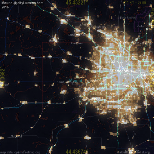
Analysis of Mound night lights 2016
Square area 10x10 km:
 0.32%
0.32%90-99
0.95%80-89
0.79%70-79
1.75%60-69
0.32%50-59
3.97%40-49
3.81%30-39
5.87%20-29
8.57%10-19
29.68%0-9
43.97%Square area 50x50 km:
4.97%90-99
5.2%80-89
3.5%70-79
4.13%60-69
5.93%50-59
5.77%40-49
4.29%30-39
2.91%20-29
4.13%10-19
6.26%0-9
52.91%Clear (daylight) street map image can be seen on geolist.org.
Map coordinates:
45° 25' 56" North, 94° 22' 9.1" West
44° 56' 11.9" North, 93° 39' 57.9" West
44° 26' 12.3" North, 92° 57' 46.6" West
Some cities around Mound sort by population:
• Minnetonka
13.1 km =8.1 mi,  101°
101°
• Chanhassen
13.5 km =8.4 mi,  127°
127°
• Waconia
13.5 km =8.4 mi,  224°
224°
• Victoria
8.7 km =5.4 mi,  177°
177°
• Orono
6.2 km =3.9 mi,  51°
51°
• Shorewood
7.3 km =4.5 mi,  123°
123°
• Minnetrista
4.1 km =2.5 mi,  272°
272°
• Medina
12.8 km =8 mi,  30°
30°
5038348 (p: 9,336)
Sources (retrieved 2019-11-25):
» Earth at Night: Flat Maps 2012, 2016