Shorewood night lights from space
Night Light of Shorewood (Minnesota) from space (United States) Src. Average luminocity for 10x10km area is 41.5476% and for 50x50km: 37.8956%.
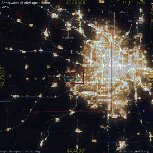
Analysis of Shorewood night lights 2016
Square area 10x10 km:
 3.17%
3.17%90-99
4.13%80-89
3.17%70-79
4.92%60-69
4.44%50-59
9.68%40-49
18.1%30-39
10.16%20-29
20.79%10-19
21.43%0-9
0%Square area 50x50 km:
8.38%90-99
8.09%80-89
4.97%70-79
5.22%60-69
6.8%50-59
6.12%40-49
4.31%30-39
2.95%20-29
4.16%10-19
6.67%0-9
42.34%Clear (daylight) street map image can be seen on geolist.org.
Map coordinates:
45° 23' 48.1" North, 94° 17' 32.1" West
44° 54' 2.9" North, 93° 35' 20.8" West
44° 24' 2.2" North, 92° 53' 9.6" West
Some cities around Shorewood sort by population:
• Eden Prairie
10.6 km =6.6 mi,  118°
118°
• Minnetonka
6.9 km =4.3 mi,  78°
78°
• Chanhassen
6.3 km =3.9 mi,  133°
133°
• Hopkins
10.3 km =6.4 mi,  74°
74°
• Mound
7.3 km =4.5 mi,  303°
303°
• Victoria
7.4 km =4.6 mi,  230°
230°
• Orono
7.9 km =4.9 mi,  351°
351°
• Minnetrista
11 km =6.8 mi,  292°
292°
5047236 (p: 7,614)
Sources (retrieved 2019-11-25):
» Earth at Night: Flat Maps 2012, 2016