Orono night lights from space
Night Light of Orono (Minnesota) from space (United States) Src. Average luminocity for 10x10km area is 25.1159% and for 50x50km: 37.8341%.
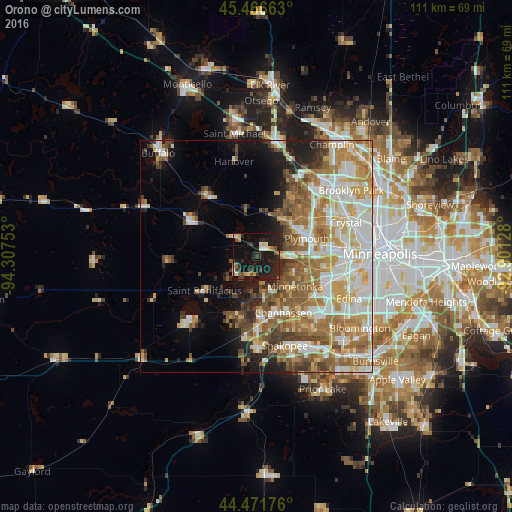
Analysis of Orono night lights 2016
Square area 10x10 km:
 1.11%
1.11%90-99
2.38%80-89
3.17%70-79
3.17%60-69
0.63%50-59
3.97%40-49
3.02%30-39
4.44%20-29
17.46%10-19
40.63%0-9
20%Square area 50x50 km:
7.86%90-99
7.99%80-89
5.12%70-79
5.44%60-69
7.11%50-59
5.9%40-49
4.26%30-39
3.03%20-29
4.16%10-19
7.54%0-9
41.59%Clear (daylight) street map image can be seen on geolist.org.
Map coordinates:
45° 27' 59.9" North, 94° 18' 27.1" West
44° 58' 16.9" North, 93° 36' 15.8" West
44° 28' 18.3" North, 92° 54' 4.6" West
Some cities around Orono sort by population:
• Plymouth
12.5 km =7.8 mi,  69°
69°
• Minnetonka
10.2 km =6.3 mi,  129°
129°
• Minnetonka Mills
13.2 km =8.2 mi,  104°
104°
• Hopkins
12.3 km =7.6 mi,  114°
114°
• Mound
6.2 km =3.9 mi,  231°
231°
• Shorewood
7.9 km =4.9 mi,  171°
171°
• Minnetrista
9.6 km =6 mi,  247°
247°
• Medina
7.3 km =4.5 mi,  13°
13°
5040332 (p: 8,006)
Sources (retrieved 2019-11-25):
» Earth at Night: Flat Maps 2012, 2016