Vinton night lights from space
Night Light of Vinton (Virginia) from space (United States) Src. Average luminocity for 10x10km area is 66.3724% and for 50x50km: 13.4212%.
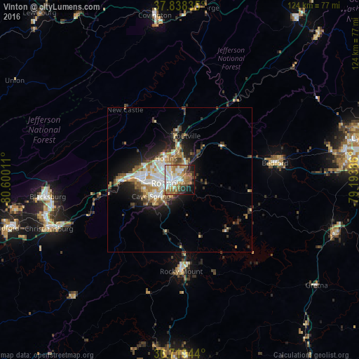
Analysis of Vinton night lights 2016
Square area 10x10 km:
 16.67%
90-99
17.86%80-89
4.93%70-79
9.18%60-69
12.41%50-59
10.37%40-49
6.12%30-39
5.27%20-29
6.97%10-19
8.84%0-9
1.36%Square area 50x50 km:
2.35%90-99
2.67%80-89
1.5%70-79
1.57%60-69
2.02%50-59
1.94%40-49
1.54%30-39
1.81%20-29
3.3%10-19
6.32%0-9
74.97%Clear (daylight) street map image can be seen on geolist.org.
Map coordinates:
37° 50' 18.1" North, 80° 36' 0.4" West
37° 16' 51.5" North, 79° 53' 49.1" West
36° 43' 10" North, 79° 11' 37.9" West
Some cities around Vinton sort by population:
• Roanoke
4.1 km =2.5 mi,  254°
254°
• Blacksburg
46.1 km =28.6 mi,  262°
262°
• Salem
14 km =8.7 mi,  275°
275°
• Cave Spring
11.8 km =7.3 mi,  239°
239°
• Christiansburg
48.4 km =30.1 mi, 249°
• Hollins
7.8 km =4.8 mi,  328°
328°
• Forest
54.5 km =33.9 mi,  80°
80°
• Bedford
33.6 km =20.9 mi, 79°
4791237 (p: 8,231)
Sources (retrieved 2019-11-25):
» Earth at Night: Flat Maps 2012, 2016