Forest night lights from space
Night Light of Forest (Virginia) from space (United States) Src. Average luminocity for 10x10km area is 39.3036% and for 50x50km: 11.4182%.
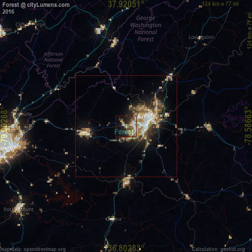
Analysis of Forest night lights 2016
Square area 10x10 km:
 4.55%
4.55%90-99
6.17%80-89
4.55%70-79
4.38%60-69
9.09%50-59
9.9%40-49
5.36%30-39
4.38%20-29
12.5%10-19
18.02%0-9
21.1%Square area 50x50 km:
1.21%90-99
1.57%80-89
1.49%70-79
1.4%60-69
2.17%50-59
2.02%40-49
1.7%30-39
2.24%20-29
2.81%10-19
5.86%0-9
77.55%Clear (daylight) street map image can be seen on geolist.org.
Map coordinates:
37° 55' 13.8" North, 79° 59' 34.4" West
37° 21' 49.5" North, 79° 17' 23.1" West
36° 48' 10.2" North, 78° 35' 11.9" West
Some cities around Forest sort by population:
• Lynchburg
14.2 km =8.8 mi,  66°
66°
• West Lynchburg
10.8 km =6.7 mi, 66°
• Timberlake
5.6 km =3.5 mi,  149°
149°
• Madison Heights
16.5 km =10.3 mi,  63°
63°
• Vinton
54.5 km =33.9 mi,  260°
260°
• Lexington
48.6 km =30.2 mi,  343°
343°
• Buena Vista
41.6 km =25.8 mi,  352°
352°
• Bedford
20.9 km =13 mi, 260°
4759556 (p: 9,106)
Sources (retrieved 2019-11-25):
» Earth at Night: Flat Maps 2012, 2016