Ville Platte night lights from space
Night Light of Ville Platte (Louisiana) from space (United States) Src. Average luminocity for 10x10km area is 22.8199% and for 50x50km: 7.3713%.
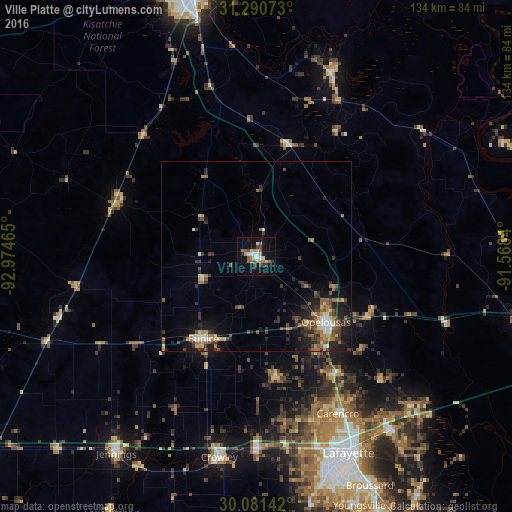
Analysis of Ville Platte night lights 2016
Square area 10x10 km:
 2.8%
2.8%90-99
2.97%80-89
2.45%70-79
3.5%60-69
2.8%50-59
4.55%40-49
2.62%30-39
2.62%20-29
2.8%10-19
19.06%0-9
53.85%Square area 50x50 km:
0.53%90-99
0.77%80-89
0.73%70-79
0.9%60-69
1.33%50-59
1.48%40-49
1.11%30-39
1.93%20-29
2.05%10-19
5.33%0-9
83.84%Clear (daylight) street map image can be seen on geolist.org.
Map coordinates:
31° 17' 26.6" North, 92° 58' 28.7" West
30° 41' 16.7" North, 92° 16' 17.5" West
30° 4' 53.1" North, 91° 34' 6.2" West
Some cities around Ville Platte sort by population:
• Opelousas
25 km =15.5 mi,  133°
133°
• Crowley
53.6 km =33.3 mi,  190°
190°
• Eunice
25.7 km =16 mi,  213°
213°
• Scott
53.1 km =33 mi,  161°
161°
• Carencro
46.4 km =28.8 mi,  152°
152°
• Rayne
50.4 km =31.3 mi,  179°
179°
• Oakdale
39.8 km =24.7 mi,  290°
290°
• Marksville
52.7 km =32.7 mi,  21°
21°
4344651 (p: 7,264)
Sources (retrieved 2019-11-25):
» Earth at Night: Flat Maps 2012, 2016