Crowley night lights from space
Night Light of Crowley (Louisiana) from space (United States) Src. Average luminocity for 10x10km area is 30.9738% and for 50x50km: 11.0381%.
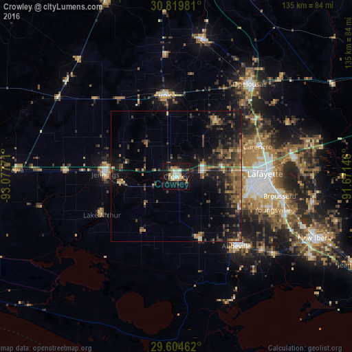
Analysis of Crowley night lights 2016
Square area 10x10 km:
 3.5%
3.5%90-99
5.77%80-89
4.72%70-79
2.97%60-69
5.42%50-59
3.67%40-49
2.45%30-39
2.97%20-29
4.2%10-19
44.06%0-9
20.28%Square area 50x50 km:
0.39%90-99
0.51%80-89
1.12%70-79
0.96%60-69
1.76%50-59
3.08%40-49
2.69%30-39
3.37%20-29
3.24%10-19
10.2%0-9
72.69%Clear (daylight) street map image can be seen on geolist.org.
Map coordinates:
30° 49' 11.3" North, 93° 4' 39.8" West
30° 12' 50.7" North, 92° 22' 28.5" West
29° 36' 16.6" North, 91° 40' 17.3" West
Some cities around Crowley sort by population:
• Lafayette
34.1 km =21.2 mi,  88°
88°
• Abbeville
35.3 km =21.9 mi,  139°
139°
• Youngsville
39.1 km =24.3 mi,  108°
108°
• Eunice
31.4 km =19.5 mi,  352°
352°
• Jennings
27.2 km =16.9 mi,  271°
271°
• Scott
27 km =16.8 mi,  84°
84°
• Carencro
33.3 km =20.7 mi,  69°
69°
• Rayne
10.5 km =6.5 mi, 77°
4321310 (p: 13,144)
Sources (retrieved 2019-11-25):
» Earth at Night: Flat Maps 2012, 2016