Carencro night lights from space
Night Light of Carencro (Louisiana) from space (United States) Src. Average luminocity for 10x10km area is 69.0751% and for 50x50km: 32.9568%.
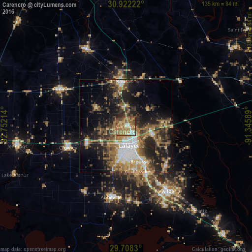
Analysis of Carencro night lights 2016
Square area 10x10 km:
 7.69%
7.69%90-99
7.51%80-89
9.71%70-79
17.95%60-69
31.87%50-59
12.64%40-49
9.16%30-39
2.01%20-29
1.47%10-19
0%0-9
0%Square area 50x50 km:
4.98%90-99
3.69%80-89
3.42%70-79
4.52%60-69
7.18%50-59
6.42%40-49
5.77%30-39
6.31%20-29
8.92%10-19
14.78%0-9
33.99%Clear (daylight) street map image can be seen on geolist.org.
Map coordinates:
30° 55' 20" North, 92° 45' 7.7" West
30° 19' 1.7" North, 92° 2' 56.4" West
29° 42' 29.9" North, 91° 20' 45.2" West
Some cities around Carencro sort by population:
• Lafayette
10.7 km =6.6 mi,  164°
164°
• Opelousas
24.3 km =15.1 mi,  352°
352°
• Youngsville
24.8 km =15.4 mi,  166°
166°
• Broussard
20.7 km =12.9 mi, 155°
• Scott
10.1 km =6.3 mi,  205°
205°
• Breaux Bridge
15.2 km =9.4 mi,  108°
108°
• Rayne
23 km =14.3 mi,  246°
246°
• Saint Martinville
29.7 km =18.5 mi,  135°
135°
4319030 (p: 8,575)
Sources (retrieved 2019-11-25):
» Earth at Night: Flat Maps 2012, 2016