Rayne night lights from space
Night Light of Rayne (Louisiana) from space (United States) Src. Average luminocity for 10x10km area is 26.8811% and for 50x50km: 22.1149%.
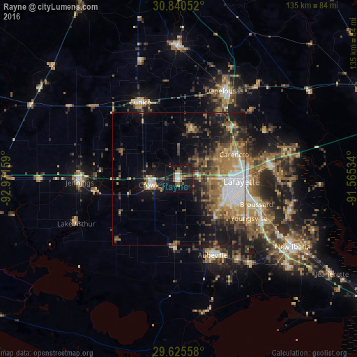
Analysis of Rayne night lights 2016
Square area 10x10 km:
 3.15%
3.15%90-99
2.27%80-89
0.87%70-79
2.97%60-69
2.27%50-59
8.39%40-49
3.67%30-39
2.45%20-29
9.62%10-19
45.8%0-9
18.53%Square area 50x50 km:
3.79%90-99
2.38%80-89
2.14%70-79
2.91%60-69
4.27%50-59
4.14%40-49
3.58%30-39
4.43%20-29
4.7%10-19
12.79%0-9
54.88%Clear (daylight) street map image can be seen on geolist.org.
Map coordinates:
30° 50' 25.9" North, 92° 58' 17.7" West
30° 14' 5.7" North, 92° 16' 6.5" West
29° 37' 32.1" North, 91° 33' 55.2" West
Some cities around Rayne sort by population:
• Lafayette
23.9 km =14.9 mi,  92°
92°
• Crowley
10.5 km =6.5 mi,  257°
257°
• Abbeville
31.7 km =19.7 mi,  155°
155°
• Youngsville
30.7 km =19.1 mi,  119°
119°
• Broussard
31.1 km =19.3 mi,  108°
108°
• Eunice
32.2 km =20 mi,  333°
333°
• Scott
16.7 km =10.4 mi, 89°
• Carencro
23 km =14.3 mi,  66°
66°
4338406 (p: 8,016)
Sources (retrieved 2019-11-25):
» Earth at Night: Flat Maps 2012, 2016