Guadalupe night lights from space
Night Light of Guadalupe (California) from space (United States) Src. Average luminocity for 10x10km area is 4.1081% and for 50x50km: 6.3604%.
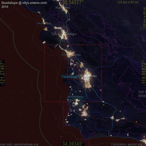
Analysis of Guadalupe night lights 2016
Square area 10x10 km:
 0%
0%90-99
0%80-89
0%70-79
0%60-69
1.1%50-59
0.55%40-49
2.01%30-39
0.73%20-29
1.47%10-19
0.73%0-9
93.41%Square area 50x50 km:
0.47%90-99
0.71%80-89
0.31%70-79
0.92%60-69
1.33%50-59
1.06%40-49
1.42%30-39
1.09%20-29
1.35%10-19
4.87%0-9
86.47%Clear (daylight) street map image can be seen on geolist.org.
Map coordinates:
35° 32' 44.8" North, 121° 16' 29.9" West
34° 58' 17.9" North, 120° 34' 18.6" West
34° 23' 36.4" North, 119° 52' 7.4" West
Some cities around Guadalupe sort by population:
• Santa Maria
12.6 km =7.8 mi,  99°
99°
• Orcutt
17.1 km =10.6 mi,  133°
133°
• Arroyo Grande
16.4 km =10.2 mi,  353°
353°
• Nipomo
11.8 km =7.3 mi,  47°
47°
• Grover Beach
17.3 km =10.7 mi,  344°
344°
• Pismo Beach
20 km =12.4 mi, 341°
• Oceano
14.6 km =9.1 mi, 345°
• Vandenberg Village
30.8 km =19.1 mi,  162°
162°
5354591 (p: 7,318)
Sources (retrieved 2019-11-25):
» Earth at Night: Flat Maps 2012, 2016