Urbana night lights from space
Night Light of Urbana (Ohio) from space (United States) Src. Average luminocity for 10x10km area is 19.724% and for 50x50km: 9.1646%.
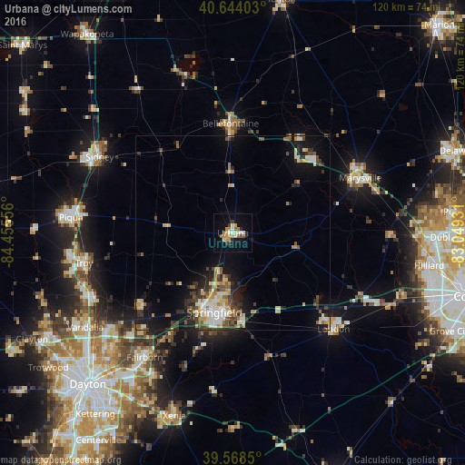
Analysis of Urbana night lights 2016
Square area 10x10 km:
 1.62%
1.62%90-99
2.6%80-89
2.76%70-79
5.19%60-69
1.46%50-59
2.76%40-49
1.3%30-39
2.44%20-29
1.46%10-19
13.8%0-9
64.61%Square area 50x50 km:
1.11%90-99
1.62%80-89
1.17%70-79
1.15%60-69
0.87%50-59
1.21%40-49
1.38%30-39
1.68%20-29
2.16%10-19
5.89%0-9
81.77%Clear (daylight) street map image can be seen on geolist.org.
Map coordinates:
40° 38' 38.5" North, 84° 27' 20" West
40° 6' 30.2" North, 83° 45' 8.7" West
39° 34' 6.6" North, 83° 2' 57.5" West
Some cities around Urbana sort by population:
• Springfield
21 km =13 mi,  193°
193°
• Fairborn
39.2 km =24.4 mi,  215°
215°
• Troy
39.1 km =24.3 mi,  258°
258°
• Marysville
35.7 km =22.2 mi,  66°
66°
• Bellefontaine
28.1 km =17.5 mi,  358°
358°
• London
35.8 km =22.2 mi,  133°
133°
• Northridge
13.2 km =8.2 mi, 189°
• New Carlisle
30.1 km =18.7 mi,  230°
230°
5174897 (p: 11,547)
Sources (retrieved 2019-11-25):
» Earth at Night: Flat Maps 2012, 2016