New Carlisle night lights from space
Night Light of New Carlisle (Ohio) from space (United States) Src. Average luminocity for 10x10km area is 16.6667% and for 50x50km: 32.5242%.
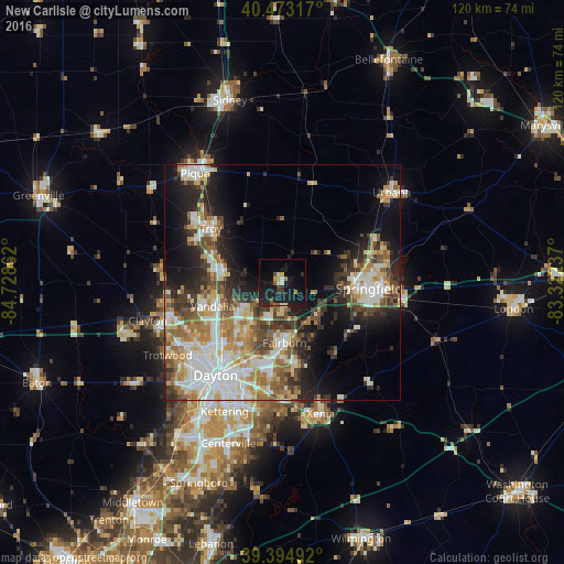
Analysis of New Carlisle night lights 2016
Square area 10x10 km:
 0.51%
0.51%90-99
1.02%80-89
3.06%70-79
1.87%60-69
1.02%50-59
1.7%40-49
1.36%30-39
1.87%20-29
7.65%10-19
33.33%0-9
46.6%Square area 50x50 km:
6.47%90-99
6.82%80-89
4.04%70-79
4.08%60-69
4.99%50-59
4.02%40-49
3.87%30-39
4.91%20-29
6.91%10-19
11.77%0-9
42.12%Clear (daylight) street map image can be seen on geolist.org.
Map coordinates:
40° 28' 23.4" North, 84° 43' 43" West
39° 56' 10.2" North, 84° 1' 31.8" West
39° 23' 41.7" North, 83° 19' 20.5" West
Some cities around New Carlisle sort by population:
• Springfield
18.5 km =11.5 mi,  94°
94°
• Huber Heights
13.3 km =8.3 mi,  219°
219°
• Fairborn
12.8 km =8 mi,  177°
177°
• Troy
19 km =11.8 mi,  307°
307°
• Riverside
19.3 km =12 mi,  205°
205°
• Vandalia
15.6 km =9.7 mi,  251°
251°
• Tipp City
12.7 km =7.9 mi,  281°
281°
• Northridge
20.5 km =12.7 mi,  225°
225°
4519497 (p: 5,693)
Sources (retrieved 2019-11-25):
» Earth at Night: Flat Maps 2012, 2016