Two Rivers night lights from space
Night Light of Two Rivers (Wisconsin) from space (United States) Src. Average luminocity for 10x10km area is 18.5636% and for 50x50km: 4.0525%.
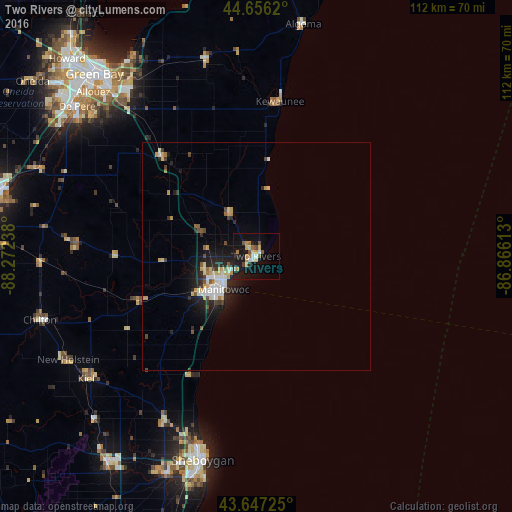
Analysis of Two Rivers night lights 2016
Square area 10x10 km:
 1.82%
1.82%90-99
2.12%80-89
2.42%70-79
2.58%60-69
3.18%50-59
2.58%40-49
2.27%30-39
0.3%20-29
2.27%10-19
23.79%0-9
56.67%Square area 50x50 km:
0.57%90-99
0.67%80-89
0.57%70-79
0.53%60-69
0.31%50-59
0.42%40-49
0.48%30-39
0.33%20-29
1.22%10-19
3.39%0-9
91.52%Clear (daylight) street map image can be seen on geolist.org.
Map coordinates:
44° 39' 22.3" North, 88° 16' 20.6" West
44° 9' 14" North, 87° 34' 9.3" West
43° 38' 50.1" North, 86° 51' 58.1" West
Some cities around Two Rivers sort by population:
• Green Bay
54.2 km =33.7 mi,  318°
318°
• Sheboygan
46.3 km =28.8 mi,  194°
194°
• Manitowoc
10.1 km =6.3 mi,  224°
224°
• De Pere
51 km =31.7 mi,  310°
310°
• Ashwaubenon
54 km =33.6 mi, 312°
• Bellevue
42.7 km =26.5 mi, 319°
• Allouez
50.6 km =31.4 mi, 315°
• Sheboygan Falls
51.1 km =31.8 mi,  203°
203°
5276609 (p: 11,331)
Sources (retrieved 2019-11-25):
» Earth at Night: Flat Maps 2012, 2016