Ashwaubenon night lights from space
Night Light of Ashwaubenon (Wisconsin) from space (United States) Src. Average luminocity for 10x10km area is 81.9349% and for 50x50km: 15.6826%.
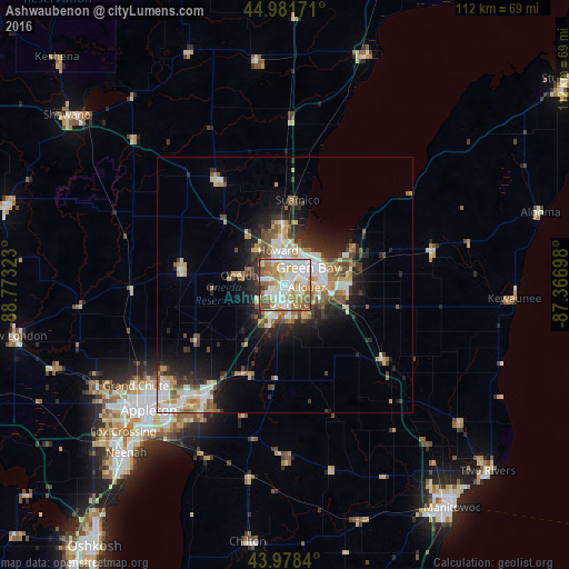
Analysis of Ashwaubenon night lights 2016
Square area 10x10 km:
 24.44%
90-99
24.29%80-89
8.1%70-79
12.7%60-69
15.08%50-59
9.52%40-49
4.13%30-39
1.75%20-29
0%10-19
0%0-9
0%Square area 50x50 km:
2.72%90-99
3.03%80-89
1.75%70-79
2.18%60-69
2.22%50-59
2.06%40-49
2.07%30-39
1.79%20-29
4.09%10-19
6.63%0-9
71.46%Clear (daylight) street map image can be seen on geolist.org.
Map coordinates:
44° 58' 54.2" North, 88° 46' 23.6" West
44° 28' 56" North, 88° 4' 12.4" West
43° 58' 42.2" North, 87° 22' 1.1" West
Some cities around Ashwaubenon sort by population:
• Green Bay
5.7 km =3.5 mi,  44°
44°
• De Pere
3.8 km =2.4 mi,  168°
168°
• Howard
7 km =4.3 mi,  348°
348°
• Kaukauna
27.8 km =17.3 mi,  215°
215°
• Bellevue
12.6 km =7.8 mi,  109°
109°
• Allouez
4.3 km =2.7 mi,  96°
96°
• Suamico
16.8 km =10.4 mi,  8°
8°
• Hobart
6.6 km =4.1 mi,  286°
286°
5244267 (p: 17,176)
Sources (retrieved 2019-11-25):
» Earth at Night: Flat Maps 2012, 2016