Allouez night lights from space
Night Light of Allouez (Wisconsin) from space (United States) Src. Average luminocity for 10x10km area is 78.827% and for 50x50km: 14.6974%.
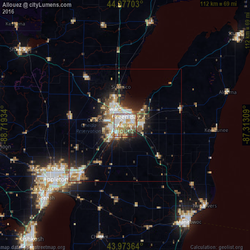
Analysis of Allouez night lights 2016
Square area 10x10 km:
 22.38%
90-99
23.49%80-89
7.62%70-79
11.75%60-69
13.49%50-59
10.16%40-49
3.81%30-39
3.17%20-29
3.65%10-19
0.48%0-9
0%Square area 50x50 km:
2.37%90-99
2.69%80-89
1.77%70-79
2.03%60-69
2.08%50-59
2.08%40-49
2.06%30-39
1.7%20-29
3.92%10-19
6.39%0-9
72.89%Clear (daylight) street map image can be seen on geolist.org.
Map coordinates:
44° 58' 37.3" North, 88° 43' 9.6" West
44° 28' 39" North, 88° 0' 58.4" West
43° 58' 25.1" North, 87° 18' 47.1" West
Some cities around Allouez sort by population:
• Green Bay
4.6 km =2.9 mi,  356°
356°
• De Pere
4.7 km =2.9 mi,  227°
227°
• Howard
9.3 km =5.8 mi,  322°
322°
• Ashwaubenon
4.3 km =2.7 mi,  276°
276°
• Kaukauna
30.1 km =18.7 mi,  222°
222°
• Bellevue
8.5 km =5.3 mi,  115°
115°
• Suamico
17.3 km =10.7 mi,  353°
353°
• Hobart
10.9 km =6.8 mi, 282°
5243770 (p: 13,930)
Sources (retrieved 2019-11-25):
» Earth at Night: Flat Maps 2012, 2016