Twinsburg night lights from space
Night Light of Twinsburg (Ohio) from space (United States) Src. Average luminocity for 10x10km area is 66.914% and for 50x50km: 48.0941%.
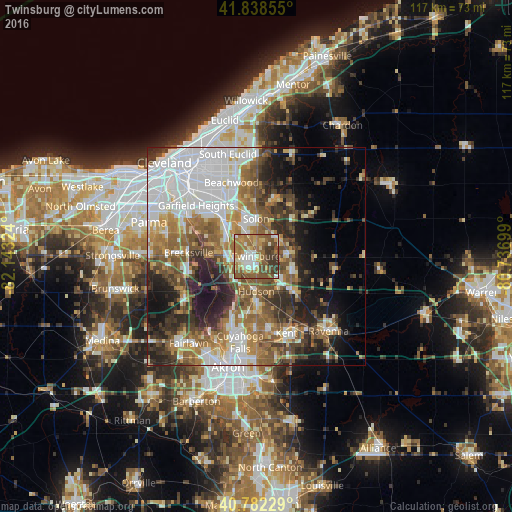
Analysis of Twinsburg night lights 2016
Square area 10x10 km:
 7.95%
7.95%90-99
13.31%80-89
6.98%70-79
9.74%60-69
22.73%50-59
18.18%40-49
11.36%30-39
9.74%20-29
0%10-19
0%0-9
0%Square area 50x50 km:
12.91%90-99
8.86%80-89
3.99%70-79
4.94%60-69
8.43%50-59
8.29%40-49
7.5%30-39
6.06%20-29
8.67%10-19
10.11%0-9
20.22%Clear (daylight) street map image can be seen on geolist.org.
Map coordinates:
41° 50' 18.8" North, 82° 8' 35.7" West
41° 18' 45.2" North, 81° 26' 24.4" West
40° 46' 56.2" North, 80° 44' 13.2" West
Some cities around Twinsburg sort by population:
• Solon
8.6 km =5.3 mi,  359°
359°
• Maple Heights
15.5 km =9.6 mi,  317°
317°
• Hudson
8.1 km =5 mi,  180°
180°
• Streetsboro
11.3 km =7 mi,  136°
136°
• Aurora
7.9 km =4.9 mi,  85°
85°
• Bedford
12 km =7.5 mi, 318°
• Macedonia
5.7 km =3.5 mi,  271°
271°
• Bedford Heights
13.7 km =8.5 mi,  327°
327°
5174550 (p: 18,872)
Sources (retrieved 2019-11-25):
» Earth at Night: Flat Maps 2012, 2016