Bedford Heights night lights from space
Night Light of Bedford Heights (Ohio) from space (United States) Src. Average luminocity for 10x10km area is 90.4847% and for 50x50km: 51.2945%.
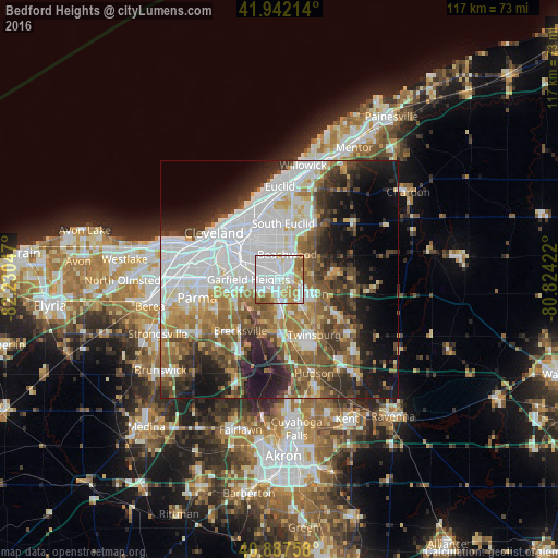
Analysis of Bedford Heights night lights 2016
Square area 10x10 km:
 45.41%
90-99
23.64%80-89
5.78%70-79
11.56%60-69
10.54%50-59
2.72%40-49
0.34%30-39
0%20-29
0%10-19
0%0-9
0%Square area 50x50 km:
16.52%90-99
10.57%80-89
3.94%70-79
4.51%60-69
7.2%50-59
7%40-49
6.68%30-39
6.24%20-29
8.45%10-19
11.62%0-9
17.27%Clear (daylight) street map image can be seen on geolist.org.
Map coordinates:
41° 56' 31.7" North, 82° 13' 49.7" West
41° 25' 1.2" North, 81° 31' 38.4" West
40° 53' 15.3" North, 80° 49' 27.2" West
Some cities around Bedford Heights sort by population:
• Garfield Heights
6.6 km =4.1 mi,  270°
270°
• Shaker Heights
6.4 km =4 mi,  352°
352°
• Solon
7.8 km =4.8 mi,  112°
112°
• Maple Heights
3.2 km =2 mi, 266°
• Warrensville Heights
2.1 km =1.3 mi,  339°
339°
• University Heights
9 km =5.6 mi, 354°
• Beachwood
5.5 km =3.4 mi,  16°
16°
• Pepper Pike
8.6 km =5.3 mi,  37°
37°
5146840 (p: 10,625)
Sources (retrieved 2019-11-25):
» Earth at Night: Flat Maps 2012, 2016