Bedford night lights from space
Night Light of Bedford (Ohio) from space (United States) Src. Average luminocity for 10x10km area is 83.7296% and for 50x50km: 52.7972%.
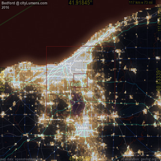
Analysis of Bedford night lights 2016
Square area 10x10 km:
 33.16%
90-99
21.09%80-89
4.42%70-79
13.78%60-69
14.29%50-59
9.86%40-49
2.72%30-39
0.68%20-29
0%10-19
0%0-9
0%Square area 50x50 km:
16.67%90-99
10.67%80-89
4.04%70-79
4.61%60-69
7.8%50-59
7.55%40-49
6.85%30-39
6.59%20-29
9.81%10-19
11.31%0-9
14.1%Clear (daylight) street map image can be seen on geolist.org.
Map coordinates:
41° 55' 6.4" North, 82° 14' 22.7" West
41° 23' 35.2" North, 81° 32' 11.4" West
40° 51' 48.6" North, 80° 50' 0.2" West
Some cities around Bedford sort by population:
• Garfield Heights
6.4 km =4 mi,  294°
294°
• Shaker Heights
9 km =5.6 mi,  359°
359°
• Solon
8 km =5 mi,  92°
92°
• Maple Heights
3.5 km =2.2 mi,  315°
315°
• Warrensville Heights
4.7 km =2.9 mi,  0°
0°
• Beachwood
8.3 km =5.2 mi,  16°
16°
• Macedonia
9.1 km =5.7 mi,  165°
165°
• Independence
8.9 km =5.5 mi,  252°
252°
5146831 (p: 12,747)
Sources (retrieved 2019-11-25):
» Earth at Night: Flat Maps 2012, 2016