Aurora night lights from space
Night Light of Aurora (Ohio) from space (United States) Src. Average luminocity for 10x10km area is 43.4201% and for 50x50km: 39.7782%.
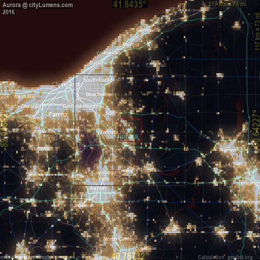
Analysis of Aurora night lights 2016
Square area 10x10 km:
 2.55%
2.55%90-99
6.97%80-89
5.78%70-79
2.55%60-69
5.1%50-59
8.33%40-49
18.71%30-39
14.97%20-29
11.05%10-19
19.9%0-9
4.08%Square area 50x50 km:
9.81%90-99
7.15%80-89
3.56%70-79
4.08%60-69
7.29%50-59
7.2%40-49
6.56%30-39
4.98%20-29
7%10-19
8.36%0-9
34%Clear (daylight) street map image can be seen on geolist.org.
Map coordinates:
41° 50' 36.6" North, 82° 2' 54.7" West
41° 19' 3.2" North, 81° 20' 43.4" West
40° 47' 14.4" North, 80° 38' 32.2" West
Some cities around Aurora sort by population:
• Kent
18.3 km =11.4 mi,  183°
183°
• Solon
11.3 km =7 mi,  315°
315°
• Hudson
11.7 km =7.3 mi,  222°
222°
• Twinsburg
7.9 km =4.9 mi,  265°
265°
• Streetsboro
8.7 km =5.4 mi, 180°
• Bedford
18 km =11.2 mi,  297°
297°
• Macedonia
13.6 km =8.5 mi, 268°
• Bedford Heights
18.8 km =11.7 mi,  306°
306°
5146233 (p: 15,838)
Sources (retrieved 2019-11-25):
» Earth at Night: Flat Maps 2012, 2016