Triangle night lights from space
Night Light of Triangle (Virginia) from space (United States) Src. Average luminocity for 10x10km area is 47.776% and for 50x50km: 28.2091%.
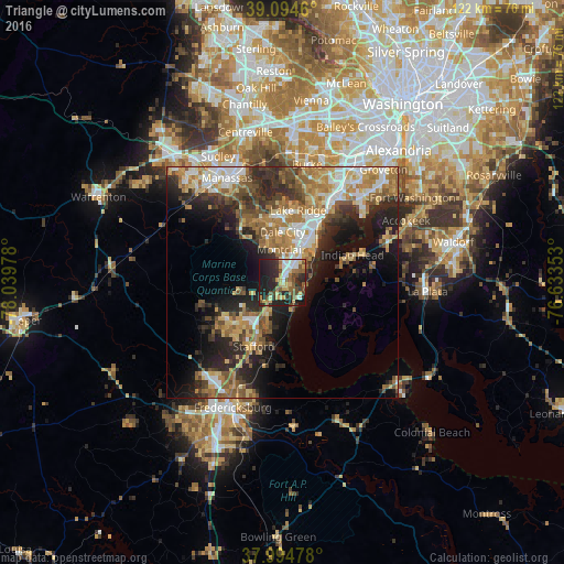
Analysis of Triangle night lights 2016
Square area 10x10 km:
 5.84%
5.84%90-99
6.82%80-89
9.9%70-79
5.84%60-69
5.19%50-59
9.09%40-49
8.44%30-39
6.82%20-29
22.89%10-19
18.83%0-9
0.32%Square area 50x50 km:
3.67%90-99
4.21%80-89
3.88%70-79
4.55%60-69
5.53%50-59
4.66%40-49
3.86%30-39
4.43%20-29
9.07%10-19
10.96%0-9
45.17%Clear (daylight) street map image can be seen on geolist.org.
Map coordinates:
39° 5' 40.6" North, 78° 2' 23.2" West
38° 32' 48.4" North, 77° 20' 11.9" West
37° 59' 41.2" North, 76° 38' 0.7" West
Some cities around Triangle sort by population:
• Dale City
10.3 km =6.4 mi,  12°
12°
• Lake Ridge
16 km =9.9 mi, 12°
• Montclair
7.1 km =4.4 mi,  357°
357°
• Cherry Hill
6.6 km =4.1 mi,  67°
67°
• Independent Hill
13.2 km =8.2 mi,  318°
318°
• Aquia Harbour
10.4 km =6.5 mi,  205°
205°
• Potomac Mills
11.6 km =7.2 mi,  18°
18°
• Dumfries
2.4 km =1.5 mi, 17°
4790025 (p: 8,188)
Sources (retrieved 2019-11-25):
» Earth at Night: Flat Maps 2012, 2016