Independent Hill night lights from space
Night Light of Independent Hill (Virginia) from space (United States) Src. Average luminocity for 10x10km area is 26.7857% and for 50x50km: 35.5874%.
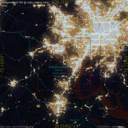
Analysis of Independent Hill night lights 2016
Square area 10x10 km:
 0.49%
0.49%90-99
0.81%80-89
2.44%70-79
1.79%60-69
10.71%50-59
8.28%40-49
5.52%30-39
4.06%20-29
10.55%10-19
21.92%0-9
33.44%Square area 50x50 km:
5.54%90-99
6.38%80-89
4.7%70-79
7.19%60-69
6.75%50-59
5.03%40-49
4.38%30-39
5.33%20-29
7.89%10-19
8.74%0-9
38.06%Clear (daylight) street map image can be seen on geolist.org.
Map coordinates:
39° 10' 59.1" North, 78° 8' 27.2" West
38° 38' 9.4" North, 77° 26' 15.9" West
38° 5' 4.6" North, 76° 44' 4.7" West
Some cities around Independent Hill sort by population:
• Dale City
11 km =6.8 mi,  89°
89°
• Manassas
13.2 km =8.2 mi,  345°
345°
• Lake Ridge
13.5 km =8.4 mi,  64°
64°
• Montclair
9 km =5.6 mi,  108°
108°
• Buckhall
10.7 km =6.6 mi,  3°
3°
• Triangle
13.2 km =8.2 mi,  138°
138°
• Potomac Mills
12.5 km =7.8 mi,  84°
84°
• Dumfries
12.2 km =7.6 mi,  128°
128°
4765594 (p: 7,419)
Sources (retrieved 2019-11-25):
» Earth at Night: Flat Maps 2012, 2016