Dumfries night lights from space
Night Light of Dumfries (Virginia) from space (United States) Src. Average luminocity for 10x10km area is 54.7776% and for 50x50km: 31.25%.
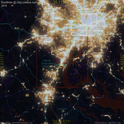
Analysis of Dumfries night lights 2016
Square area 10x10 km:
 7.79%
7.79%90-99
10.23%80-89
8.44%70-79
6.17%60-69
11.04%50-59
9.74%40-49
8.93%30-39
7.14%20-29
21.43%10-19
9.09%0-9
0%Square area 50x50 km:
4.59%90-99
5.13%80-89
4.38%70-79
5.13%60-69
5.9%50-59
4.74%40-49
4.05%30-39
4.66%20-29
9.12%10-19
10.67%0-9
41.64%Clear (daylight) street map image can be seen on geolist.org.
Map coordinates:
39° 6' 55" North, 78° 1' 52.2" West
38° 34' 3.4" North, 77° 19' 40.9" West
38° 0' 56.8" North, 76° 37' 29.7" West
Some cities around Dumfries sort by population:
• Dale City
7.9 km =4.9 mi,  10°
10°
• Lake Ridge
13.6 km =8.5 mi, 11°
• Montclair
4.9 km =3 mi,  348°
348°
• Cherry Hill
5.3 km =3.3 mi,  87°
87°
• Triangle
2.4 km =1.5 mi,  197°
197°
• Independent Hill
12.2 km =7.6 mi,  308°
308°
• Aquia Harbour
12.8 km =8 mi, 204°
• Potomac Mills
9.2 km =5.7 mi,  18°
18°
4756643 (p: 5,217)
Sources (retrieved 2019-11-25):
» Earth at Night: Flat Maps 2012, 2016