Montclair night lights from space
Night Light of Montclair (Virginia) from space (United States) Src. Average luminocity for 10x10km area is 67.7581% and for 50x50km: 36.5382%.
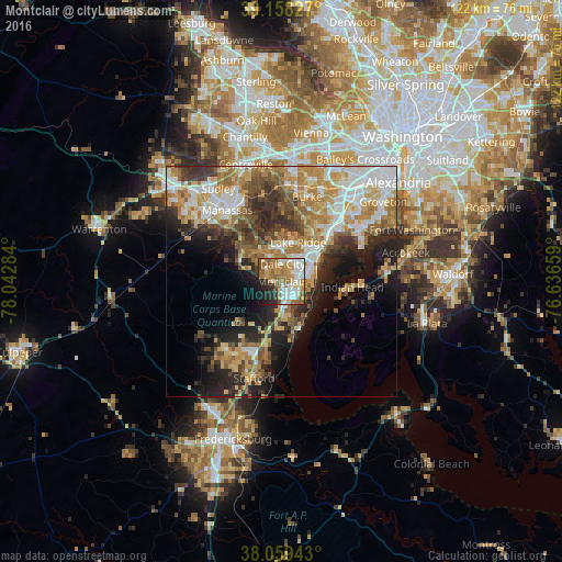
Analysis of Montclair night lights 2016
Square area 10x10 km:
 15.1%
15.1%90-99
16.4%80-89
6.17%70-79
11.36%60-69
18.83%50-59
8.77%40-49
3.08%30-39
3.41%20-29
10.06%10-19
6.82%0-9
0%Square area 50x50 km:
6.49%90-99
6.64%80-89
5.03%70-79
6.39%60-69
6.76%50-59
5.03%40-49
4.17%30-39
4.99%20-29
8.33%10-19
9.74%0-9
36.45%Clear (daylight) street map image can be seen on geolist.org.
Map coordinates:
39° 9' 29.8" North, 78° 2' 34.2" West
38° 36' 39.4" North, 77° 20' 23" West
38° 3' 33.9" North, 76° 38' 11.7" West
Some cities around Montclair sort by population:
• Dale City
3.8 km =2.4 mi,  40°
40°
• Lake Ridge
9.3 km =5.8 mi,  23°
23°
• Lorton
14.2 km =8.8 mi, 43°
• Cherry Hill
7.8 km =4.8 mi,  125°
125°
• Triangle
7.1 km =4.4 mi,  177°
177°
• Independent Hill
9 km =5.6 mi,  288°
288°
• Potomac Mills
5.6 km =3.5 mi,  45°
45°
• Dumfries
4.9 km =3 mi,  168°
168°
4773677 (p: 19,570)
Sources (retrieved 2019-11-25):
» Earth at Night: Flat Maps 2012, 2016