Aquia Harbour night lights from space
Night Light of Aquia Harbour (Virginia) from space (United States) Src. Average luminocity for 10x10km area is 46.0617% and for 50x50km: 21.2341%.
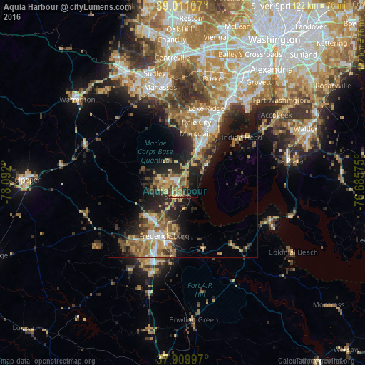
Analysis of Aquia Harbour night lights 2016
Square area 10x10 km:
 4.38%
4.38%90-99
4.71%80-89
5.19%70-79
10.23%60-69
12.18%50-59
11.2%40-49
5.52%30-39
6.33%20-29
16.4%10-19
16.4%0-9
7.47%Square area 50x50 km:
2.42%90-99
2.68%80-89
3.1%70-79
3.23%60-69
4.28%50-59
3.96%40-49
2.74%30-39
3.09%20-29
7.13%10-19
10.57%0-9
56.79%Clear (daylight) street map image can be seen on geolist.org.
Map coordinates:
39° 0' 39.9" North, 78° 5' 31.2" West
38° 27' 45.4" North, 77° 23' 19.9" West
37° 54' 35.9" North, 76° 41' 8.7" West
Some cities around Aquia Harbour sort by population:
• Dale City
20.5 km =12.7 mi,  19°
19°
• Fredericksburg
18.8 km =11.7 mi,  199°
199°
• Montclair
17 km =10.6 mi,  14°
14°
• Cherry Hill
16 km =9.9 mi,  41°
41°
• Triangle
10.4 km =6.5 mi,  25°
25°
• Independent Hill
19.7 km =12.2 mi,  347°
347°
• Potomac Mills
22 km =13.7 mi, 22°
• Dumfries
12.8 km =8 mi, 24°
4744645 (p: 6,727)
Sources (retrieved 2019-11-25):
» Earth at Night: Flat Maps 2012, 2016