Thompson night lights from space
Night Light of Thompson (Connecticut) from space (United States) Src. Average luminocity for 10x10km area is 11.7857% and for 50x50km: 10.1%.
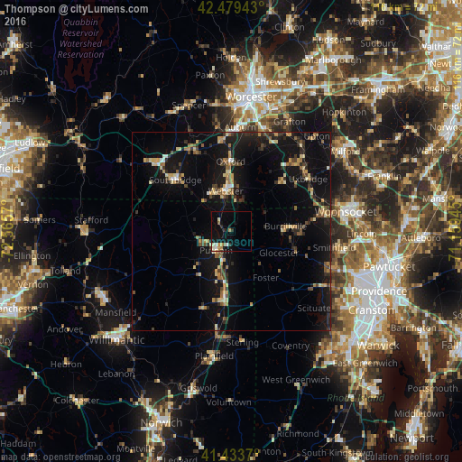
Analysis of Thompson night lights 2016
Square area 10x10 km:
 0.79%
0.79%90-99
2.38%80-89
1.43%70-79
2.54%60-69
0.48%50-59
0.95%40-49
0%30-39
1.27%20-29
1.59%10-19
12.86%0-9
75.71%Square area 50x50 km:
0.32%90-99
0.76%80-89
1.65%70-79
1.08%60-69
1.24%50-59
1.49%40-49
1.34%30-39
1.32%20-29
3%10-19
13.77%0-9
74.02%Clear (daylight) street map image can be seen on geolist.org.
Map coordinates:
42° 28' 45.9" North, 72° 33' 56.5" West
41° 57' 31.4" North, 71° 51' 45.3" West
41° 26' 1.3" North, 71° 9' 34" West
Some cities around Thompson sort by population:
• Southbridge
19.1 km =11.9 mi,  312°
312°
• Killingly Center
13.4 km =8.3 mi,  182°
182°
• Charlton
21.6 km =13.4 mi,  335°
335°
• Webster
10.3 km =6.4 mi,  351°
351°
• Dudley
11.1 km =6.9 mi,  329°
329°
• Putnam
6.2 km =3.9 mi,  218°
218°
• Douglas
14.7 km =9.1 mi,  43°
43°
• Oxford
17.6 km =10.9 mi,  359°
359°
4844184 (p: 9,358)
Sources (retrieved 2019-11-25):
» Earth at Night: Flat Maps 2012, 2016