Southbridge night lights from space
Night Light of Southbridge (Massachusetts) from space (United States) Src. Average luminocity for 10x10km area is 20.4841% and for 50x50km: 13.0551%.
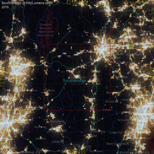
Analysis of Southbridge night lights 2016
Square area 10x10 km:
 2.06%
2.06%90-99
2.38%80-89
5.08%70-79
1.43%60-69
1.9%50-59
2.38%40-49
1.27%30-39
3.17%20-29
2.22%10-19
25.24%0-9
52.86%Square area 50x50 km:
1.67%90-99
2%80-89
1.98%70-79
1.67%60-69
1.9%50-59
1.62%40-49
1.5%30-39
1.52%20-29
2.84%10-19
8.12%0-9
75.17%Clear (daylight) street map image can be seen on geolist.org.
Map coordinates:
42° 35' 41.5" North, 72° 44' 11.5" West
42° 4' 30.4" North, 72° 2' 0.3" West
41° 33' 3.8" North, 71° 19' 49" West
Some cities around Southbridge sort by population:
• Auburn
21 km =13 mi,  50°
50°
• Charlton
8.5 km =5.3 mi,  37°
37°
• Webster
13 km =8.1 mi,  102°
102°
• Dudley
9.2 km =5.7 mi,  111°
111°
• Thompson
19.1 km =11.9 mi,  132°
132°
• Putnam
20.5 km =12.7 mi,  149°
149°
• Oxford
14.7 km =9.1 mi,  71°
71°
• Spencer
19.1 km =11.9 mi,  10°
10°
4951594 (p: 19,030)
Sources (retrieved 2019-11-25):
» Earth at Night: Flat Maps 2012, 2016