Charlton night lights from space
Night Light of Charlton (Massachusetts) from space (United States) Src. Average luminocity for 10x10km area is 13.6773% and for 50x50km: 16.6309%.
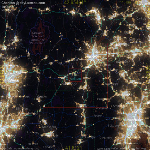
Analysis of Charlton night lights 2016
Square area 10x10 km:
 0%
0%90-99
0%80-89
2.42%70-79
0.61%60-69
1.82%50-59
3.18%40-49
2.12%30-39
1.36%20-29
2.88%10-19
14.7%0-9
70.91%Square area 50x50 km:
2.1%90-99
2.64%80-89
2.38%70-79
2.12%60-69
2.78%50-59
2.34%40-49
1.97%30-39
2.49%20-29
4.26%10-19
9.24%0-9
67.68%Clear (daylight) street map image can be seen on geolist.org.
Map coordinates:
42° 39' 17.7" North, 72° 40' 23.5" West
42° 8' 8.3" North, 71° 58' 12.3" West
41° 36' 43.6" North, 71° 16' 1" West
Some cities around Charlton sort by population:
• Southbridge
8.5 km =5.3 mi,  217°
217°
• Auburn
12.9 km =8 mi,  59°
59°
• Webster
12.1 km =7.5 mi,  142°
142°
• Dudley
10.6 km =6.6 mi,  161°
161°
• Leicester
13.3 km =8.3 mi,  22°
22°
• Sutton
17.2 km =10.7 mi,  84°
84°
• Oxford
8.9 km =5.5 mi,  103°
103°
• Spencer
12.2 km =7.6 mi,  351°
351°
4932823 (p: 12,764)
Sources (retrieved 2019-11-25):
» Earth at Night: Flat Maps 2012, 2016