Thomasville night lights from space
Night Light of Thomasville (Georgia) from space (United States) Src. Average luminocity for 10x10km area is 59.5367% and for 50x50km: 5.9341%.
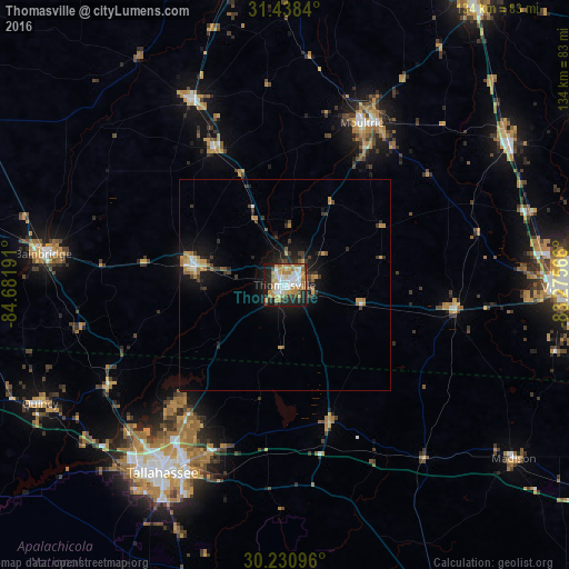
Analysis of Thomasville night lights 2016
Square area 10x10 km:
 13.29%
90-99
12.59%80-89
5.42%70-79
15.21%60-69
12.94%50-59
1.92%40-49
3.5%30-39
5.07%20-29
12.24%10-19
17.48%0-9
0.35%Square area 50x50 km:
0.73%90-99
0.71%80-89
0.48%70-79
1.25%60-69
1.09%50-59
0.46%40-49
0.54%30-39
1.32%20-29
1.32%10-19
4.55%0-9
87.56%Clear (daylight) street map image can be seen on geolist.org.
Map coordinates:
31° 26' 18.2" North, 84° 40' 54.9" West
30° 50' 11.7" North, 83° 58' 43.6" West
30° 13' 51.5" North, 83° 16' 32.4" West
Some cities around Thomasville sort by population:
• Tallahassee
52.9 km =32.9 mi,  213°
213°
• Valdosta
66.7 km =41.4 mi,  90°
90°
• Moultrie
42.2 km =26.2 mi,  25°
25°
• Bainbridge
57.4 km =35.7 mi,  277°
277°
• Cairo
21.8 km =13.5 mi, 282°
• Quincy
64.1 km =39.8 mi,  244°
244°
• Adel
62.6 km =38.9 mi,  57°
57°
• Camilla
49.1 km =30.5 mi,  333°
333°
4226348 (p: 18,742)
Sources (retrieved 2019-11-25):
» Earth at Night: Flat Maps 2012, 2016