Bainbridge night lights from space
Night Light of Bainbridge (Georgia) from space (United States) Src. Average luminocity for 10x10km area is 39.75% and for 50x50km: 2.818%.
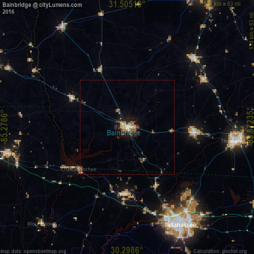
Analysis of Bainbridge night lights 2016
Square area 10x10 km:
 4.72%
4.72%90-99
3.67%80-89
2.45%70-79
10.49%60-69
9.79%50-59
6.12%40-49
6.12%30-39
6.12%20-29
5.24%10-19
37.06%0-9
8.22%Square area 50x50 km:
0.2%90-99
0.15%80-89
0.15%70-79
0.65%60-69
0.54%50-59
0.32%40-49
0.62%30-39
0.76%20-29
0.55%10-19
2.18%0-9
93.88%Clear (daylight) street map image can be seen on geolist.org.
Map coordinates:
31° 30' 18.7" North, 85° 16' 43" West
30° 54' 13.7" North, 84° 34' 31.7" West
30° 17' 55" North, 83° 52' 20.5" West
Some cities around Bainbridge sort by population:
• Tallahassee
58.9 km =36.6 mi,  151°
151°
• Albany
85 km =52.8 mi,  28°
28°
• Thomasville
57.4 km =35.7 mi,  97°
97°
• Moultrie
81 km =50.3 mi,  67°
67°
• Cairo
35.7 km =22.2 mi,  94°
94°
• Marianna
63.8 km =39.6 mi,  256°
256°
• Quincy
35.2 km =21.9 mi,  181°
181°
• Camilla
50.3 km =31.3 mi,  43°
43°
4180775 (p: 12,507)
Sources (retrieved 2019-11-25):
» Earth at Night: Flat Maps 2012, 2016