Temperance night lights from space
Night Light of Temperance (Michigan) from space (United States) Src. Average luminocity for 10x10km area is 32.2192% and for 50x50km: 27.0532%.
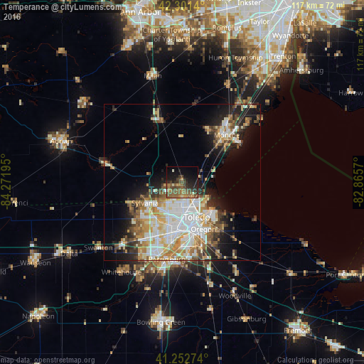
Analysis of Temperance night lights 2016
Square area 10x10 km:
 0.16%
0.16%90-99
2.27%80-89
1.14%70-79
4.55%60-69
6.82%50-59
15.1%40-49
9.74%30-39
7.95%20-29
9.25%10-19
18.02%0-9
25%Square area 50x50 km:
6.13%90-99
6%80-89
3.33%70-79
3.61%60-69
3.85%50-59
3%40-49
2.85%30-39
2.92%20-29
4.73%10-19
8.73%0-9
54.87%Clear (daylight) street map image can be seen on geolist.org.
Map coordinates:
42° 18' 5" North, 84° 16' 19" West
41° 46' 45.2" North, 83° 34' 7.8" West
41° 15' 9.9" North, 82° 51' 56.5" West
Some cities around Temperance sort by population:
• Toledo
12.9 km =8 mi,  174°
174°
• Oregon
16.5 km =10.3 mi,  155°
155°
• Monroe
20.8 km =12.9 mi,  42°
42°
• Sylvania
13.7 km =8.5 mi,  240°
240°
• Lambertville
5.1 km =3.2 mi,  253°
253°
• Rossford
18.8 km =11.7 mi,  178°
178°
• South Monroe
18 km =11.2 mi, 43°
• Northwood
20.8 km =12.9 mi, 156°
5011989 (p: 8,517)
Sources (retrieved 2019-11-25):
» Earth at Night: Flat Maps 2012, 2016