Northwood night lights from space
Night Light of Northwood (Ohio) from space (United States) Src. Average luminocity for 10x10km area is 60.2776% and for 50x50km: 26.9269%.
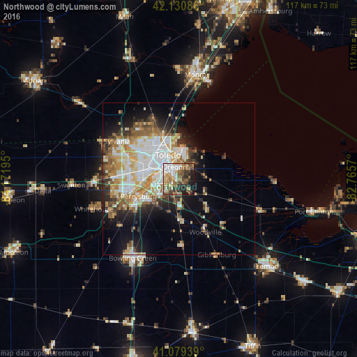
Analysis of Northwood night lights 2016
Square area 10x10 km:
 12.99%
90-99
9.9%80-89
5.52%70-79
7.14%60-69
15.1%50-59
13.15%40-49
9.74%30-39
8.28%20-29
10.71%10-19
7.31%0-9
0.16%Square area 50x50 km:
6.11%90-99
5.88%80-89
3.13%70-79
3.61%60-69
3.95%50-59
3.15%40-49
2.79%30-39
2.9%20-29
4.39%10-19
8.37%0-9
55.71%Clear (daylight) street map image can be seen on geolist.org.
Map coordinates:
42° 7' 51.1" North, 84° 10' 19" West
41° 36' 26.2" North, 83° 28' 7.8" West
41° 4' 45.8" North, 82° 45' 56.5" West
Some cities around Northwood sort by population:
• Toledo
9.6 km =6 mi,  311°
311°
• Perrysburg
14.3 km =8.9 mi,  247°
247°
• Oregon
4.3 km =2.7 mi,  339°
339°
• Sylvania
23.8 km =14.8 mi,  301°
301°
• Maumee
16.2 km =10.1 mi, 252°
• Lambertville
22 km =13.7 mi,  323°
323°
• Temperance
20.8 km =12.9 mi, 336°
• Rossford
7.9 km =4.9 mi,  272°
272°
5165069 (p: 5,350)
Sources (retrieved 2019-11-25):
» Earth at Night: Flat Maps 2012, 2016