Rossford night lights from space
Night Light of Rossford (Ohio) from space (United States) Src. Average luminocity for 10x10km area is 89.1607% and for 50x50km: 28.2118%.
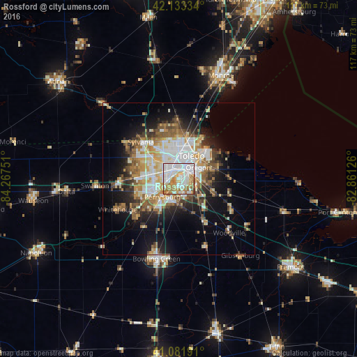
Analysis of Rossford night lights 2016
Square area 10x10 km:
 38.96%
90-99
24.84%80-89
8.93%70-79
10.39%60-69
15.26%50-59
1.62%40-49
0%30-39
0%20-29
0%10-19
0%0-9
0%Square area 50x50 km:
6.11%90-99
5.91%80-89
3.21%70-79
3.76%60-69
4.26%50-59
3.33%40-49
3.06%30-39
3.18%20-29
4.97%10-19
10.18%0-9
52.03%Clear (daylight) street map image can be seen on geolist.org.
Map coordinates:
42° 8' 0" North, 84° 16' 3" West
41° 36' 35.2" North, 83° 33' 51.8" West
41° 4' 54.9" North, 82° 51' 40.5" West
Some cities around Rossford sort by population:
• Toledo
6.1 km =3.8 mi,  7°
7°
• Perrysburg
7.9 km =4.9 mi,  221°
221°
• Oregon
7.5 km =4.7 mi,  59°
59°
• Sylvania
17.3 km =10.7 mi,  314°
314°
• Maumee
9.1 km =5.7 mi,  234°
234°
• Lambertville
18.1 km =11.2 mi,  343°
343°
• Waterville
17.6 km =10.9 mi, 226°
• Northwood
7.9 km =4.9 mi,  92°
92°
5168673 (p: 6,512)
Sources (retrieved 2019-11-25):
» Earth at Night: Flat Maps 2012, 2016