South Monroe night lights from space
Night Light of South Monroe (Michigan) from space (United States) Src. Average luminocity for 10x10km area is 45.2651% and for 50x50km: 17.0056%.
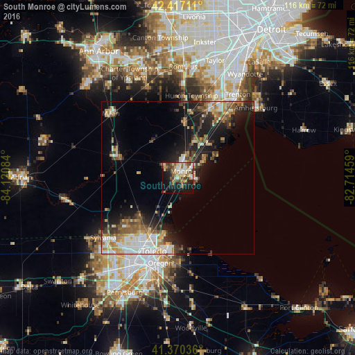
Analysis of South Monroe night lights 2016
Square area 10x10 km:
 6.67%
6.67%90-99
7.62%80-89
7.94%70-79
6.03%60-69
7.46%50-59
7.14%40-49
5.4%30-39
8.41%20-29
9.52%10-19
22.86%0-9
10.95%Square area 50x50 km:
2.77%90-99
3.19%80-89
1.77%70-79
1.98%60-69
2.43%50-59
2.46%40-49
2.27%30-39
2.53%20-29
4.65%10-19
9.57%0-9
66.38%Clear (daylight) street map image can be seen on geolist.org.
Map coordinates:
42° 25' 1.6" North, 84° 7' 15" West
41° 53' 45.2" North, 83° 25' 3.8" West
41° 22' 13.3" North, 82° 42' 52.5" West
Some cities around South Monroe sort by population:
• Toledo
28.2 km =17.5 mi,  203°
203°
• Oregon
28.6 km =17.8 mi,  191°
191°
• Monroe
2.8 km =1.7 mi,  35°
35°
• Woodhaven
30.7 km =19.1 mi,  28°
28°
• Lambertville
22.6 km =14 mi,  230°
230°
• Flat Rock
24.6 km =15.3 mi, 25°
• Temperance
18 km =11.2 mi,  223°
223°
• Milan
30.4 km =18.9 mi,  313°
313°
5010569 (p: 6,433)
Sources (retrieved 2019-11-25):
» Earth at Night: Flat Maps 2012, 2016