Tarrytown night lights from space
Night Light of Tarrytown (New York) from space (United States) Src. Average luminocity for 10x10km area is 60.4643% and for 50x50km: 52.5284%.
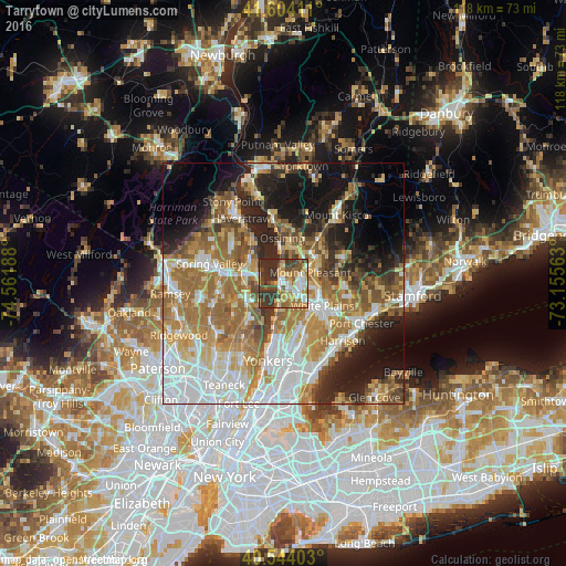
Analysis of Tarrytown night lights 2016
Square area 10x10 km:
 9.9%
9.9%90-99
8.93%80-89
9.09%70-79
11.69%60-69
11.85%50-59
5.68%40-49
11.04%30-39
20.94%20-29
10.88%10-19
0%0-9
0%Square area 50x50 km:
11.58%90-99
9.65%80-89
6.28%70-79
8.45%60-69
11.97%50-59
7.12%40-49
5.18%30-39
5.37%20-29
8.57%10-19
12.42%0-9
13.42%Clear (daylight) street map image can be seen on geolist.org.
Map coordinates:
41° 36' 14.8" North, 74° 33' 42.8" West
41° 4' 34.4" North, 73° 51' 31.5" West
40° 32' 38.5" North, 73° 9' 20.3" West
Some cities around Tarrytown sort by population:
• Greenburgh
5 km =3.1 mi,  164°
164°
• Dobbs Ferry
7 km =4.3 mi,  189°
189°
• Sleepy Hollow
1 km =0.6 mi,  1°
1°
• Briarcliff Manor
8.3 km =5.2 mi,  20°
20°
• Pleasantville
8.4 km =5.2 mi,  41°
41°
• Nyack
5.2 km =3.2 mi,  287°
287°
• Irvington
4.2 km =2.6 mi, 190°
• Hartsdale
8.1 km =5 mi,  141°
141°
5140538 (p: 11,560)
Sources (retrieved 2019-11-25):
» Earth at Night: Flat Maps 2012, 2016