Pleasantville night lights from space
Night Light of Pleasantville (New York) from space (United States) Src. Average luminocity for 10x10km area is 58.3994% and for 50x50km: 43.5635%.
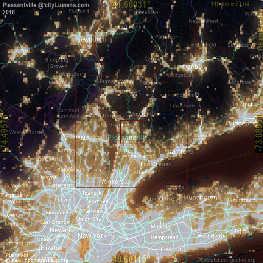
Analysis of Pleasantville night lights 2016
Square area 10x10 km:
 3.08%
3.08%90-99
4.71%80-89
15.1%70-79
10.71%60-69
11.85%50-59
12.99%40-49
17.21%30-39
15.1%20-29
9.25%10-19
0%0-9
0%Square area 50x50 km:
6.23%90-99
6.99%80-89
5.55%70-79
7.43%60-69
10.75%50-59
7.47%40-49
5.41%30-39
5.72%20-29
8.8%10-19
15.07%0-9
20.59%Clear (daylight) street map image can be seen on geolist.org.
Map coordinates:
41° 39' 37.1" North, 74° 29' 44.7" West
41° 7' 58.3" North, 73° 47' 33.5" West
40° 36' 4.1" North, 73° 5' 22.2" West
Some cities around Pleasantville sort by population:
• White Plains
11.3 km =7 mi,  167°
167°
• Ossining
6.7 km =4.2 mi,  300°
300°
• North Castle
9.1 km =5.7 mi,  85°
85°
• Tarrytown
8.4 km =5.2 mi,  221°
221°
• Mount Kisco
9.6 km =6 mi,  34°
34°
• Sleepy Hollow
7.6 km =4.7 mi,  226°
226°
• Briarcliff Manor
3 km =1.9 mi, 298°
• Nyack
11.5 km =7.1 mi,  245°
245°
5131757 (p: 7,173)
Sources (retrieved 2019-11-25):
» Earth at Night: Flat Maps 2012, 2016