Tara Hills night lights from space
Night Light of Tara Hills (California) from space (United States) Src. Average luminocity for 10x10km area is 58.1396% and for 50x50km: 33.7386%.
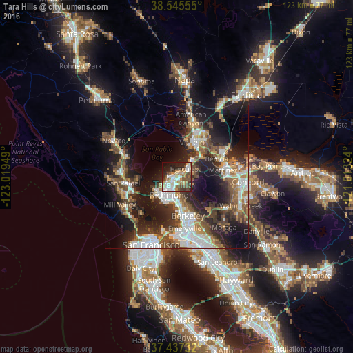
Analysis of Tara Hills night lights 2016
Square area 10x10 km:
 10.39%
90-99
13.31%80-89
5.68%70-79
11.04%60-69
7.95%50-59
10.06%40-49
9.58%30-39
4.38%20-29
14.77%10-19
10.23%0-9
2.6%Square area 50x50 km:
6.64%90-99
5.8%80-89
2.08%70-79
4.19%60-69
4.55%50-59
5.48%40-49
6.29%30-39
5.49%20-29
10.41%10-19
18.73%0-9
30.33%Clear (daylight) street map image can be seen on geolist.org.
Map coordinates:
38° 32' 44" North, 123° 1' 10.2" West
37° 59' 36.7" North, 122° 18' 58.9" West
37° 26' 14.4" North, 121° 36' 47.7" West
Some cities around Tara Hills sort by population:
• Richmond
7 km =4.3 mi,  203°
203°
• San Pablo
4.3 km =2.7 mi,  216°
216°
• Hercules
3.6 km =2.2 mi,  42°
42°
• El Cerrito
8.7 km =5.4 mi,  177°
177°
• Pinole
2 km =1.2 mi,  51°
51°
• El Sobrante
2.6 km =1.6 mi,  134°
134°
• Rodeo
6.2 km =3.9 mi, 44°
• Kensington
9.8 km =6.1 mi,  161°
161°
5401121 (p: 5,126)
Sources (retrieved 2019-11-25):
» Earth at Night: Flat Maps 2012, 2016